
POSTPONED due to weather: Ask Questions and Learn More About the Low-Level Helicopter Flying Above the Mississippi Alluvial Plain
Media: Please join the U.S. Geological Survey, CGG Airborne and various partners for a demonstration of the low-flying helicopter and description of what scientists are seeking in and around the Mississippi Alluvial Plain.
What: Public Open House
When: Due to the Jonesboro-area weather forecast for Thursday, February 7, this event is being postponed to a date to be determined.
Where: Arkansas Air Center, Jonesboro Municipal Airport, 3901 Lindbergh Dr. # C, Jonesboro, Arkansas, 72401
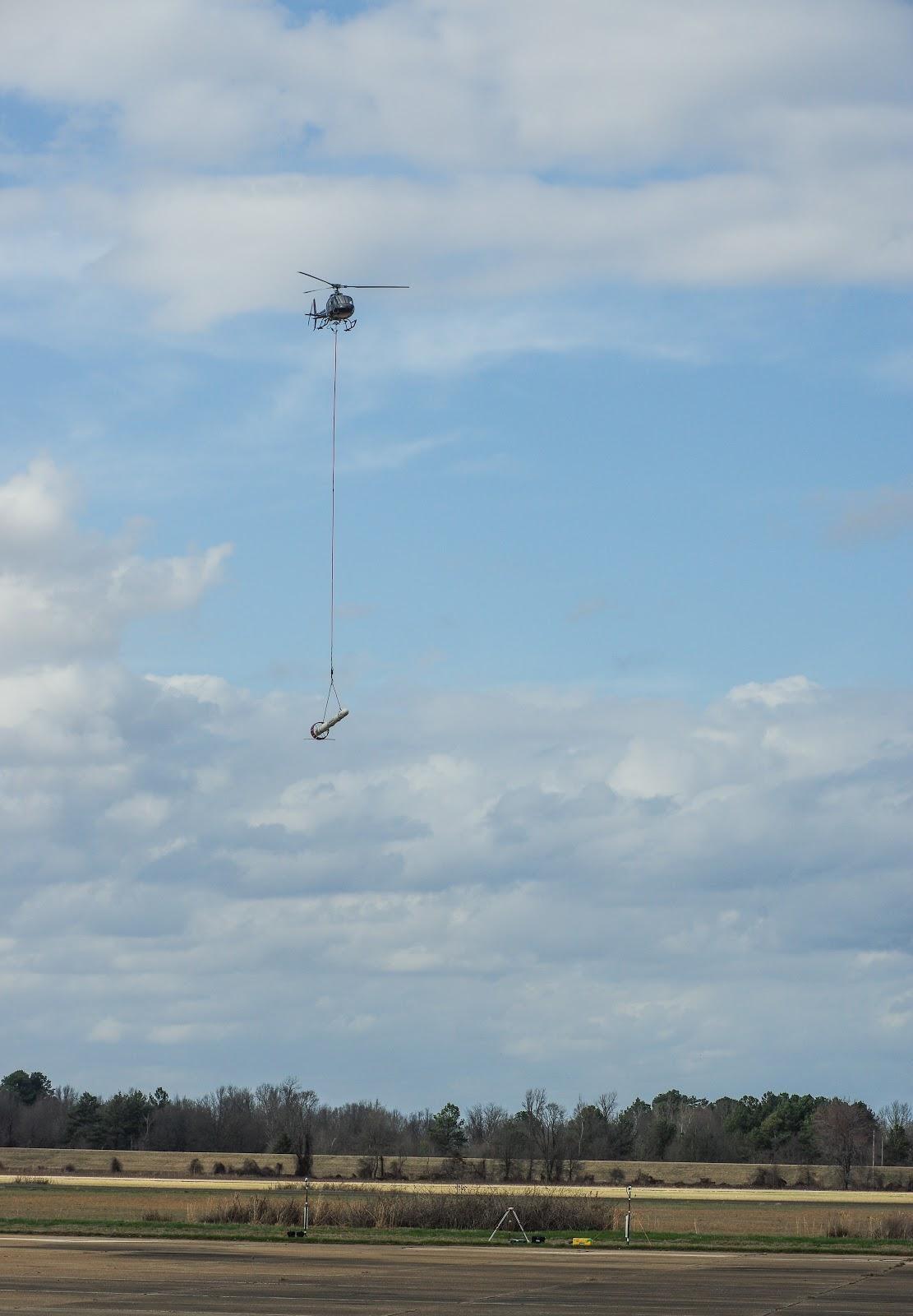
Why: Attendees of the open house will be able to ask USGS scientists and partners about the study, and see a demonstration of the low-level helicopter. Since early November 2018, the helicopter has been flying over parts of seven states in the Mississippi Alluvial Plain, or MAP, to acquire a more robust picture of aquifers in the area. This portion of the survey will last for several weeks.
This high-resolution, airborne geophysical survey, coordinated by USGS scientists in partnership with local agencies, will provide critical data for the evaluation and management of groundwater resources in the region. The survey represents the second phase of the study as initial flights and data acquisition over the MAP started in February 2018 using the same helicopter system.
The helicopter and geophysical instrumentation arrived in Blytheville, Arkansas, on January 31. The helicopter and device it tows beneath will be visible in the area as soon as February 1. Once testing is complete, daily production flights in the region will begin. The crew will operate out of Blytheville, Arkansas, for approximately one and a half weeks, followed by Sikeston, Missouri, for another one and a half weeks.
CGG Airborne of Ontario, Canada, under contract to the USGS, will make the daytime, low-level flights over more than 20 million acres within the MAP, including a buffer around the entire area. Experienced pilots who are specially trained and approved for low-level flying will operate the aircraft. All flights are coordinated with the Federal Aviation Administration to ensure accordance with U.S. law.
The MAP is one of the most productive agricultural regions in the nation and depends on groundwater for irrigation. It constitutes the third largest area of irrigated cropland in the U.S., consisting of approximately 29,000 square miles, or 19 million acres, and includes parts of Missouri, Tennessee, Arkansas, Mississippi, Louisiana, Kentucky and Illinois.
Instruments on the helicopter will collect information about the geology in shallow aquifers of the region. When the data analysis is complete, resulting state-of-the-art maps will help USGS researchers understand the aquifer system that supports groundwater resources at depths up to about 300 feet underground.
This survey will be flown along mainly east-west lines at about 200 feet above the ground. The helicopter will have an attached electromagnetic instrument housed in a cylinder called a bird that is towed about 100 feet beneath the aircraft.
The helicopter will also carry scientific instruments including a magnetometer and a gamma-ray spectrometer. None of the instruments pose a health risk to people or animals.
The survey is being conducted by the USGS Water Availability and Use Program as part of the Mississippi Alluvial Plain Regional Water Availability Study. More information about this project can be found online.


Get Our News
These items are in the RSS feed format (Really Simple Syndication) based on categories such as topics, locations, and more. You can install and RSS reader browser extension, software, or use a third-party service to receive immediate news updates depending on the feed that you have added. If you click the feed links below, they may look strange because they are simply XML code. An RSS reader can easily read this code and push out a notification to you when something new is posted to our site.